East Kameng district
Where the Kameng River Flows Through Tribal Lands
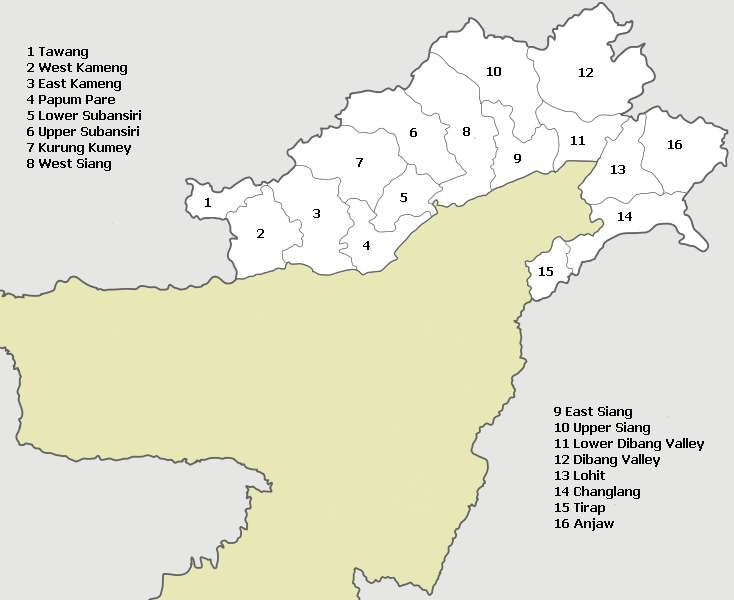
The terrain of East Kameng district is a study in verticality and verdure, defined by its steep hills and the Kameng River carving its path through the landscape. This district in Arunachal Pradesh holds a significant historical footprint, marked by diverse tribal communities whose lives are intimately connected to the forest and its resources.
History & Context
Formerly part of the larger Kameng Frontier Division during the British colonial era, East Kameng's administrative boundaries have evolved over time. It was officially established as a separate district on June 1, 1980. The region has historically been home to various tribal groups, each with distinct languages, customs, and traditional governance systems. The Nyishi, Aka (Hrusso), Miji (Sajolang), and Puroik are among the major communities, shaping the cultural fabric of the district. Their semi-nomadic past and dependence on forest produce for sustenance have left a strong imprint on their present-day practices and beliefs.
What Makes It Distinctive
East Kameng is defined by the profound relationship between its inhabitants and their natural surroundings, particularly evident in the traditional Nyokum Yullo festival of the Nyishi people. This pre-harvest festival, typically observed in late February, involves prayers to the spirit of the earth, Nyokum, for communal harmony and a good harvest. Offerings, often including mithun (gayal) sacrifices, are made, and traditional dances are performed. Another distinctive aspect is the traditional architecture, especially among the Aka tribe, characterized by houses built on stilts, often with intricate bamboo and wood craftsmanship, designed to adapt to the hilly terrain and heavy rainfall. The district is also home to the Pakke Tiger Reserve, a critical conservancy for diverse flora and fauna, including tigers, clouded leopards, and various hornbill species, reflecting the rich biodiversity of the Eastern Himalayas.
Best Time to Visit
The period from October to March is generally considered the most favorable time to visit. During these months, the weather is cool and clear, offering good visibility for mountain views and comfortable conditions for exploring. Temperatures range from approximately 10°C to 25°C. April and May bring warmer weather, with pre-monsoon showers beginning towards the end of May. The monsoon season, from June to September, experiences heavy rainfall, leading to potential road blockages and limiting outdoor activities.
How to Reach
Seppa, the district headquarters, is not directly accessible by air or rail. The nearest major airport is Tezpur Airport (TEZ) in Assam, approximately 180 km away, a journey that can take 5-7 hours by road. The nearest major railway station is Rangapara North Junction (RPN) in Assam, about 170 km from Seppa, with a road travel time of 4-6 hours. From Tezpur or Rangapara, shared taxis and private vehicles are available to Seppa. The road network within Arunachal Pradesh is improving but can be challenging, especially during the monsoon season.
Permits & Entry
For Indian citizens from outside Arunachal Pradesh, an Inner Line Permit (ILP) is mandatory to enter the state. These can be obtained online through the Arunachal Pradesh government portal or in person at designated offices in major cities like Guwahati, Tezpur, or Lilabari. Foreign nationals require a Protected Area Permit (PAP). Information is not officially published or may change. Visitors are advised to confirm locally before travelling. Specific entry fees and timings apply for Pakke Tiger Reserve, and detailed information should be checked with the Forest Department or at the park entrance upon arrival.
Nearby Attractions
- Pakke Tiger Reserve: Known for its conservation efforts for tigers and hornbills, offering excellent wildlife viewing opportunities.
- Pakhui Wildlife Sanctuary: Adjacent to Pakke Tiger Reserve, providing further chances to observe the region's diverse wildlife.
- Sessa Orchid Sanctuary: Hosts over 200 species of orchids, showcasing the botanical richness of the Eastern Himalayas.
- Bomdila: A picturesque town in West Kameng known for its Buddhist monasteries and panoramic views of the Himalayan ranges.
Traveller Tips
- Connectivity: Mobile network coverage can be sporadic outside Seppa. BSNL generally offers better reach in remote areas.
- ATMs: Seppa has a few ATMs, but it's advisable to carry sufficient cash, especially for remote village visits, as digital payment options are limited.
- Dress Code: Pack layers. Evenings can be cool, and respectful attire is appreciated when visiting local communities or sacred sites.
- Altitude: While Seppa is not at an extreme altitude, some areas can be higher. Stay hydrated and be aware of potential altitude sickness symptoms.
- Homestays: Consider opting for homestays in villages to experience local culture and cuisine firsthand, supporting community tourism.
- Photography: Always ask for permission before photographing people, especially during cultural events or within homes.
- Language: While Hindi and English are understood in tourist areas, learning a few basic phrases in Nyishi or other local languages can be enriching and appreciated.
- Plastic Waste: Practice responsible tourism by minimizing plastic waste and ensuring proper disposal, as waste management infrastructure is limited.
Frequently asked
Related
Plan Your Journey with Living Roots Expeditions
Travel Northeast India with a private guide, hand-picked hosts, and an itinerary shaped around your interests — culture, wildlife, festivals, or slow discovery. If this subject is why you are travelling, see our Northeast India tour packages.