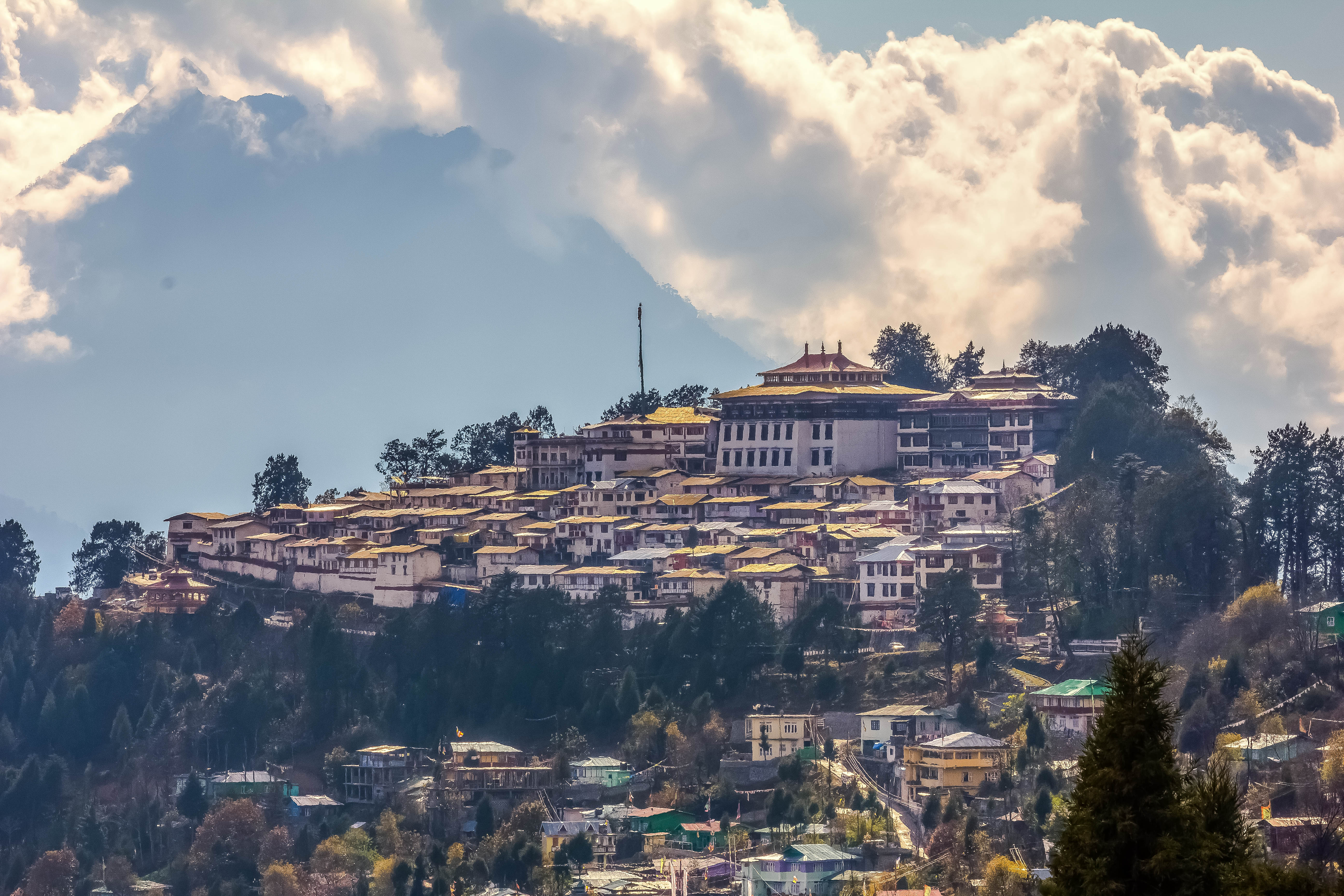
Tawang district

Home to the world's second-largest monastery and the vibrant Monpa culture, nestled in the Eastern Himalayas.

At a glance
state
Arunachal Pradesh
country
India
pincode
790104
area km2
2172
altitude m
3048
main river
Tawang Chu
population
49977
best season
March-June, September-October
established
1984-10-06
headquarters
Tawang
major tribes
Monpa
district name
Tawang
major religion
Tibetan Buddhism
major languages
Monpa (Bhoti), Hindi, English
population year
2011

Overview

Tawang is the westernmost district of Arunachal Pradesh in Northeast India. It is renowned for its immense natural beauty, strategically important location, and as a major center of Tibetan Buddhism. The district is characterized by high-altitude Himalayan ranges, deep valleys, and the rich cultural heritage of the Monpa people, who are its predominant inhabitants.

History

The history of Tawang is deeply intertwined with that of Tibet. Prior to the 20th century, the region, though inhabited by the Monpa people, was administered from Lhasa through the Tawang Monastery. The area is historically significant as the birthplace of Tsangyang Gyatso, the 6th Dalai Lama, who was born in Urgelling Monastery in 1683.

In 1914, the Simla Accord established the McMahon Line as the new boundary between British India and Tibet. This line placed Tawang within British-administered India. However, Tibetan authorities continued to collect taxes and exert influence in the area for several decades. It was only in 1951 that Major Ralengnao 'Bob' Khathing of the Indian Frontier Administrative Service formally brought Tawang under Indian administration.

The district was the site of significant conflict during the 1962 Sino-Indian War. The Chinese People's Liberation Army advanced through the Sela and Bum La passes, occupying the area temporarily before withdrawing. Today, the region maintains a heavy military presence due to its sensitive location on the Line of Actual Control (LAC) with China. Tawang district was officially formed on October 6, 1984, by carving it out of the West Kameng district.

Geography and Climate

Tawang is situated at an average elevation of about 3,048 meters (10,000 feet). The district's topography is mountainous, with towering peaks, including the Gorichen Peak (the highest in Arunachal Pradesh), and deep gorges carved by rivers like the Tawang Chu. It is bordered by Tibet (China) to the north, Bhutan to the southwest, and the West Kameng district of Arunachal Pradesh to the east.

Entry into the district from the rest of India is primarily via the Sela Pass, which stands at an altitude of approximately 4,170 meters (13,700 feet). Other significant passes include the Bum La Pass on the border with China. The climate is alpine, with temperate summers and long, harsh winters characterized by heavy snowfall that can often cut off road access.

Culture and Demographics

According to the 2011 Census, Tawang has a population of 49,977. The district is predominantly inhabited by the Monpa tribe, who practice Tibetan Buddhism of the Gelug school. Their language, also known as Monpa, belongs to the Tibeto-Burman family.

The focal point of cultural and religious life is the Tawang Monastery, or Galden Namgyal Lhatse. Founded in 1680-81 by Merak Lama Lodre Gyatso, it is the second-largest Buddhist monastery in the world after the Potala Palace in Lhasa. It houses hundreds of monks and is a significant pilgrimage site.

Major festivals celebrated with great enthusiasm include Losar (the Tibetan New Year) and Torgya, a monastic festival held to ward off evil spirits and pray for prosperity.

Key Sites of Interest

  • Tawang Monastery: An iconic 17th-century monastery overlooking the Tawang valley.
  • Sela Pass and Lake: A high-altitude mountain pass and a sacred lake that serves as the gateway to Tawang.
  • Jaswant Garh War Memorial: A memorial dedicated to Rifleman Jaswant Singh Rawat, a hero of the 1962 Sino-Indian War.
  • Nuranang Falls (Jang Falls): A spectacular waterfall located near the town of Jang.
  • Urgelling Monastery: The birthplace of the 6th Dalai Lama.
  • Bum La Pass: A high-altitude pass on the Indo-China border, accessible to tourists with a special permit from the Indian Army.
  • Sangestar Tso (Madhuri Lake): A high-altitude lake formed by an earthquake, famous for its scenic beauty.

Visitor Information

Due to its proximity to the international border, access to Tawang is regulated. Indian citizens (excluding residents of Arunachal Pradesh) require an Inner Line Permit (ILP). Foreign nationals need a Protected Area Permit (PAP). These permits can be obtained online or from designated government offices. The primary mode of access is by road from Guwahati in Assam or Tezpur, a journey that typically takes two or more days.

Living Roots Expert Notes

Expedition Leader Insights

Permits are Mandatory: Do not attempt to travel to Tawang without a valid Inner Line Permit (for Indians) or Protected Area Permit (for foreigners). Arrange this well in advance online or via an agent. Permits are checked at multiple points starting from Bhalukpong, and entry will be denied without the correct documents.

Acclimatize Properly: The journey involves a rapid ascent to high altitudes, especially when crossing Sela Pass (13,700 ft). Rushing the trip is a common mistake that leads to Acute Mountain Sickness (AMS). Plan for at least one night halt at a lower altitude like Dirang (around 4,900 ft) to help your body adjust before proceeding to Tawang (10,000 ft).

Respect Local and Military Sensitivities: Tawang is a deeply religious and a strategically sensitive military zone. When visiting monasteries, always walk clockwise (parikrama), dress modestly, and ask for permission before photographing monks or religious ceremonies. Photography and videography of army camps, convoys, and border installations are strictly prohibited and can lead to serious trouble.

Choose Your Season Wisely: Autumn (late September to early November) offers the best combination of clear blue skies, post-monsoon greenery, and pleasant daytime temperatures. Spring (April to early June) is beautiful with rhododendron blooms but can have occasional rain. Winter (December to February) is for the adventurous; expect extreme cold, heavy snowfall, and the risk of road closures at Sela Pass.

Frequently asked

How do I get a permit for Tawang?
Indian citizens (from outside Arunachal Pradesh) need an Inner Line Permit (ILP), obtainable online from the official Arunachal Pradesh government portal or offline from government offices in cities like Guwahati, Tezpur, and Delhi. Foreign nationals need a Protected Area Permit (PAP), which is typically arranged through an authorized Indian tour operator.
What is the historical significance of Tawang Monastery?
Founded in 1680-81, Tawang Monastery (Galden Namgyal Lhatse) is the second-largest Buddhist monastery in the world. It is the main center for the Gelug school of Tibetan Buddhism in the region and historically administered the Tawang area on behalf of the government in Lhasa.
What is the best way to reach Tawang?
The most common way to reach Tawang is by road. The journey usually starts from Guwahati (approx. 500 km) or Tezpur (approx. 330 km) in Assam. The nearest major airport is in Guwahati (LGBI Airport), and the nearest major railway station is in Tezpur. The drive takes at least two days with an overnight halt, typically in Dirang or Bomdila.
What is Sela Pass and why is it important?
Sela Pass is a high-altitude mountain pass at about 4,170 meters (13,700 ft). It is the primary route connecting Tawang district with the rest of India. The pass is considered sacred by Buddhists and is often covered in snow during winter, which can temporarily close the road.
Was Tawang always part of India?
The Tawang tract was defined as being within British India by the 1914 Simla Accord's McMahon Line. However, it was administered by Tibet until 1951, when India formally established its administration over the area. China disputes the legality of the McMahon Line and claims Tawang as part of South Tibet.

Related

Sources

  1. [1]
    History | Tawang District, Government of Arunachal PradeshOfficialTawang District Administration
  2. [2]
  3. [3]
    Tawang - Arunachal TourismOfficialDepartment of Tourism, Government of Arunachal Pradesh
  4. [4]
    Arunachal Pradesh Inner Line PermitOfficialGovernment of Arunachal Pradesh
  5. [5]
  6. [6]
    District Census Handbook: TawangOfficialDirectorate of Census Operations, Arunachal Pradesh
Email Us